In the early 17th century, the celebrated London engraver William Hole (d. 1624), also known for his work as the chief designer of coins at the Royal Mint in the Tower of London, created some of the strangest maps of Britain ever made. These odd, otherworldly pictorial maps of counties were commissioned to illustrate Poly-Olbion, a vast 15,000-line topographical poem by Michael Dayton (1563-1631) celebrating the countryside, folklore, history and antiquities of England and Wales, published in two parts, in 1612 and 1622.
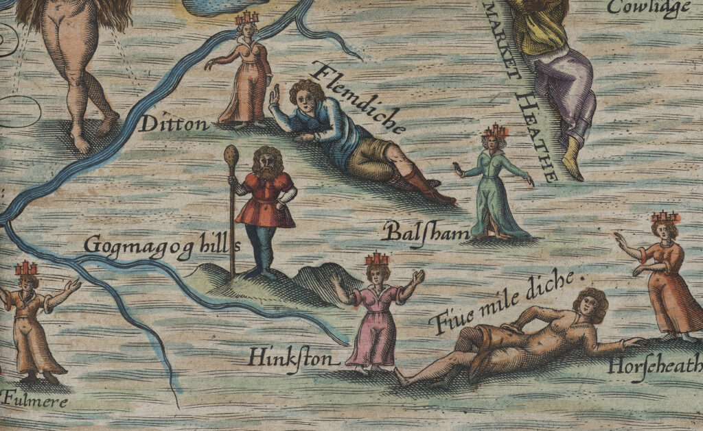
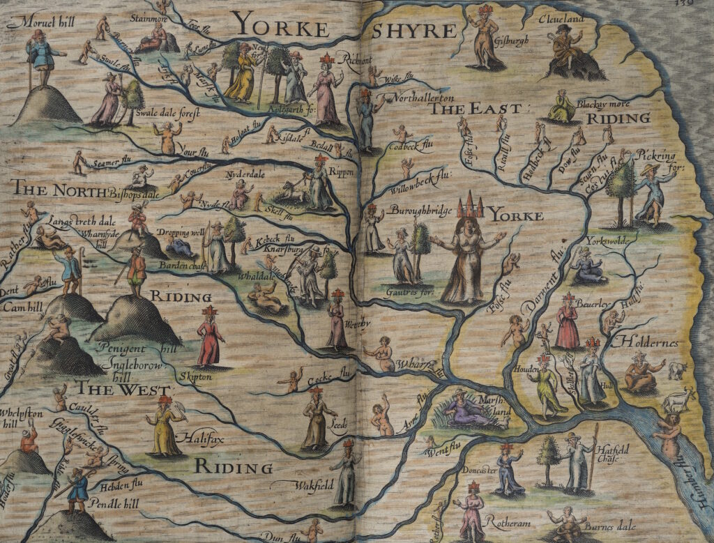
In Drayton and Hole’s collective vision, Britain is presented as an animated, mythologized landscape, bustling with otherworldly beings: the magical shadow of empirical, mercantile mapmaking, it plots an ethereal world of fairy and pagan divinity infusing the rich earth and gushing brooks of Merry England. Every feature is anthropomorphised, a rhetorical device termed prosopopeia: the rolling English hills and craggy Welsh mountains represented as stout country gentlemen, the rivers and streams as naked water nymphs and bearded, weed-crowned gods, the forests and woods as elegantly-clad huntresses, complete with curled hunting horns and bows and arrows. Human geography is minimal, with the exception of historical cities and towns, represented by both male and female figures crowned by miniature buildings and frequently clutching appropriate and often complex emblems (Cambridge, for example, is represented as a maiden with a grail in one hand, a solar emblem in the other, a castle on her head, and milk-laden breasts).
The son of a tanner, Michael Drayton was born in a tumbledown cottage in the sleepy Warwickshire village of Hartshill, but educated and elevated in society by the wealthy Goodere family, at whose home at Polesworth Hall, a few miles down the river, he became ‘a proper goodly page’ at the age of ten. By 1590, he moved to London, settling in a ‘bay-windowe house’ in Fleet Street, to become a poet. He quickly secured aristocratic patrons and his career flourished with works like England’s Heroicall Epistles, a book of imagined letters between famous historical lovers. Before long, he was acclaimed as the ‘English Ovid’ and wreathed Poet Laureate.
It was his ‘strange Herculean labour,’ Poly-Olbion, however, thirty long, hard years in the making, which remains his magnum opus. Drayton’s ‘incomparable poem,’ wrote E.M. Forster in Howards End. The creation of this extraordinary work, one of the longest of its kind in the English language, seems to have driven him almost to madness, certainly to utter despair at points in its birthing. He had to struggle to get the second section published in 1622, following a series of increasingly vitriolic exchanges with publishers who were wary after slow sales of the first volume: ‘It went not so fast away in the Sale, as some of their beastly and abominable trash,” he grumbles in the preface, “the Booksellers and I are in Terms: They are a Company of base Knaves, whom I both scorn and kick at.’
The maps and poetry of the Poly-Olbion emerged from the Renaissance reawakening of interest in chorography: a branch of classical geography concerned with regional description, as opposed to the geographical study of the universal, of the entire known world. According to Ptolemy’s original definition, chorography ‘selects certain places from the whole to treat by themselves more fully, even dealing with the smallest details, such as harbours, villages, districts, tributaries, and such like…its concern is to paint a true likeness, and not merely give exact position and size.” Chorography then, was the art of describing the local and, in England, it became inevitably tethered to the counties, with their discrete topographies and land-based traditions and folklore.
The most influential chorographical text of the Elizabethan period was first published in 1586: Britannia by the antiquarian William Camden (1551–1623), Drayton’s close friend. A monumental county-by-county survey tracing the history of each locality from Roman times, it had an extraordinary impact. Never before had Britain been described in such rich detail rooted in such thorough methodology:
‘I have travailed over all England for the most part,’ Camden wrote of his research, ‘I have conferred with most skillfull observers in each county, I have studiously read over our owne countrie writers, old and new, all Greeke and Latine authors which have once made mention of Britaine. I have had conference with learned men in other parts of Christendome: I have beene diligent in the Records of this Realme.’
Camden’s great chorographic project had a profound influence on Poly-Olbion, both as an indispensable source of topography and local history, and as a model for Drayton’s soaring ambition for his epic poem, which would comprise ‘a chorographicall description of tracts, rivers, mountains, forests, and other parts of this renowned isle of Great Britain with intermixture of the most remarkeable stories, antiquities, wonders, rarities, pleasures, and commodities of the same.’
Drayton copied the perambulatory structure of Camden’s journey around the shires, dividing his poem into thirty sections or ‘Songs,’ each describing one, two or three counties, accompanied by a double-paged map, to produce a poetical survey of the entire country, beginning in the Channel or French Islands and ending in Cumberland. Scotland was planned, but never completed. Despite its expansive aims, there is no rush to Drayton’s journey, and his use of 12-syllable Alexandrine meter slows the pace of the poem down to a gentle amble, giving it a ‘kind of heavy dignity like a Lord Mayor’s coach,’ to quote Drayton’s Edwardian biographer, Oliver Elton.
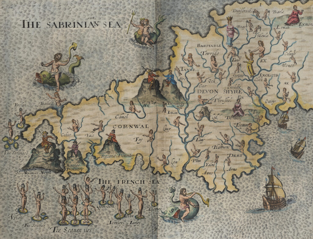
As ‘especiall helps’ for the reader struggling with the chorographical scope of his work, Drayton included a short introductory summary at the beginning of each song ~ ‘First the Argument,’ he wrote, ‘to direct thee still, where thou art, and through what Shires the Muse makes her journey.’ He also enlisted the brilliant young historian and lawyer, John Selden (1584-1654) to contribute detailed historical notes ‘to explaine every hard matter of history’ and asked the cartographer who had worked on the 1607 edition of Britannia, William Hole, to provide maps ‘lively delineating…every Mountaine, Forrest, River, and Valley; expressing in their sundry postures; their loves, delights, and naturall situations.’ Hole also engraved a portrait of Henry, Prince of Wales, Drayton’s patron, and a decorative frontispiece, depicting the great goddess figure of Albion, clothed in a rippling map of her land, wearing pearls from Dartmoor, Ravenglass and Conwy, and surrounded by four subordinate invading monarchs: Brute, the first Briton, Julius Caesar, the Saxon Hengist and William the Conqueror.

This revolutionary idea of the land as the permanent, unchanging power to whom all, even kings and queens, bow down, defines Poly-Olbion, and through the device of prosopopeia – explained by the rhetorician Angel Day in 1592 as ‘when to things without life wee frame an action, speech or person fitting a man’ – it is the land itself that narrates its stories, its many myths, memories, histories and topographies. Drayton’s main concern is to quicken the landscape, to give it life, and a multiplicity of natural voices crowds the poem, vividly depicted in Hole’s maps: personified seas, rivers, brooks, springs, mountains, hills, valleys, woods, groves, plains, fenland, and caves sing, declaim, debate, bicker, fall in love, marry, boast, grieve and exchange sympathy. This is a very particular ontological treatment of the pastoral. The silvery dryads who live in the forests are not simply wood nymphs – they are simultaneously the forests themselves, every thorn, twig, acorn and pearl of sap vivified and articulate. And within this sentient non-human landscape there is a strict hierarchy, mirroring English society, the valleys and hills ruled by the tallest mountains, the streams and lesser floods by the great rivers: the Thames, the Severn, the Trent, the Humber.
In a country largely lacking in reliable roads, those navigable rivers were of vital import to the flow of trade and communication, and the poem gushes with riverine song, the maps veined in water. ‘The rivers count for everything, the roads for nothing,’ declared The Times in 1937.
In Song IV, for example, a singing competition takes place between the Welsh and English rivers, each boasting the superior history: the prize, the Isle of Lundy. The rivers Isis and Thame marry in Song XV, crowned in wild flowers from the water meadows and banks – Harebells, Daffodils, Primroses, Sweet William, Sops in wine, Cowslips, Columbines, Thyme. In Song XXI, the Gogmagog Hill, with his thick rural dialect, lounging across the flats, comically woos the elegant River Granta.
The most poignant sections of the poem, however, bemoan the impact of deforestation, not simply the waste of resources, but also the destruction of beauty and history: Chiltern shivering with the destruction of his ‘Beechen woods’ in Song XV, and, in Song II, the great oaks of Blackmore Forest in Dorset felled by ‘mans devouring hand.’ His lament for the old forest of Andredsweald, covering vast swathes of Kent, Sussex and Surrey, which had been ravaged since the 16th century to provide timber for the Navy and charcoal for the iron industry:
‘Jove’s oak, the warlike ash, veined elm, the softer beech,
Short hazel, maple plain, light asp, the bending wych,
Tough holly, and smooth birch, must altogether burn:
What should the builder serve, supplies the forger’s turn;
When under public good, base private gain takes hold,
And we poor woeful woods, to ruin lastly sold.’
As Drayton’s poem and Hole’s maps progress from place to place, from Merionethshyre to Rutlandshyre, Devonshyre to London, an encyclopaedic textual repository of the concerns of the early 17th century is slowly amassed. Every imaginable subject is addressed: Robin Hood, sea monsters, Druidry, herbalism, the decline of wolves, English saints, root vegetables, Roman builders, New World explorers, the song birds of Arden Forest, Flemish immigrants, the great sheep of the Cotswolds, the art of falconry. County by county, shire town by shire town, the rich and plural tapestry of Britain is woven by Drayton into a vital record of the nation at a point of change and fragmentation, on the eve of the Civil War. For Hole, rendering this complexity in map form was impossible, and he reduces the cacophony of history and folklore to just the speakers themselves, rising from the landscape they embody, bold and magical, beckoning the wary reader into the somewhat daunting depths of the poem.
The maps and their significance were forgotten for many years, however, the first actual reference to their centrality to the work being published as late as 1854, when an anonymous essayist in the Retrospective Review wrote that among the ‘certain attractions of durable nature’ of Poly-Olbion, there is ‘a series of poetic maps which are as singular in their construction.’ When the 1876 edition of the poem neglected to reprint the maps, A.B. Grosart blasted the decision: ‘to deprive us of the maps is downright robbery. Historically, and in relation to the poem, they are as indispensable as an atlas in following a Livingstone or a Stanley.’
It was not until 1933, when J.W. Hebel published the fourth volume of his edition of Drayton’s complete works, that Poly-Olbion was finally reprinted with its full cartographic content, prompting a reviewer in the Times Literary Supplement (August 31, 1933) to write that to ‘read the Poly-Olbion without the maps would be to miss not only a chance of understanding what Drayton would be at, but also a gentle, inexhaustable pleasure.’
Perhaps the most heartfelt modern reappraisal of both Hole’s maps and Drayton’s poetics, however, was written in October 1941 by Harold Hannyngton Child, the wartime editor of the Times Literary Supplement. Writing from a shattered Fleet Street in the middle of the Blitz, Child wrote of being transported and comforted by the poem’s bucolic nationalism and Hole’s cartographic vision of a unified, mythic landscape:
There are reasons, and not very far to seek, why Poly-Olbion should win large numbers of new admirers in a Great Britain that is fighting for its life for the second time in less than thirty years…Here is a Great Britain sure of herself, of her long, honourable history, and —if she will but keep herself unspotted by vice and greed and oppression—sure of her heroic future. There is no doubt in her that good is good and evil is evil, and that descendants of all those warriors and saints and heroes must uphold the good against the evil. On this unquestioning, Elizabethan confidence, so instinctive that it called for no direct, still less for defiant, expression, the harassed modern may lie back in restorative and heartening relaxation…If he could see, as we see, that country battered and defiled by barbarians, he would understand what a comfort and a stay he had left us in his great heroic, homely poem.

Win a copy of Albion’s Glorious Ile: A Hand-Colouring Book from the Songs of Poly-Olbion by Anne Louise Avery
The wonderful folks over at Unicorn Publishing have offered a copy of Anne’s excellent colouring book for a lucky #FolkloreThursday newsletter subscriber this month!
“‘Of Albions glorious Ile the Wonders … I write’
–Michael Drayton, Poly-Olbion (1612)
Rivers and floods sing their rich histories; ancient forests lament the axe; mountains threaten war —Michael Drayton’s epic topographical poem, Poly-Olbion,reveals a hidden, otherworldly Britain: a Jacobean Faerie Land teeming with nymphs, kings, giants and dragons.
This hand-colouring book features the fantastical maps of William Hole, published in 1612 and 1622 within the two volumes of Poly-Olbion — each map illustrating one of the ‘Songs’ of the epic poem. In the words of Michael Drayton: “every Mountaine, Forrest, River, and Valley, expressing in their sundry postures; their loves, delights, and naturall situations.” The art of hand-colouring was popular during the 17th century and beyond and many of the original copies of these maps were subsequently hand coloured using water-colours. Here create your own modern-day hand-tinted maps of this glorious Ile!”
Sign up for the #FolkloreThursday newsletter to enter (valid November 2018; UK & ROI only).
The book can be purchased here, or read about it in The Guardian.